Thursday, September 28, 2017

Calgary: D-Touring through the +15 Skywalk

Have you ever had opportunity to visit a maze?  Did you get lost?  Were you overwhelmed?  Why did you go in the first place: as a dare?  for some group event?  was it part of a tour?

Well, did you know that Calgary has it's very own public maze?  It's called the +15 Skywalk and it's accessible to any member of the willing public from early in the morning to late at night.  Located in the heart of Calgary's Downtown it forms an integral part of the lifeblood of the City Centre!

The +15 is a labyrinth of above-street walkways that link many of the key high-rises in the Downtown, enabling employees and visitors to navigate the City Centre in a weather-protected environment.  This is especially helpful when the outdoor temperatures plummet to sub-zero, when there is a frigid north wind being funnelled down the streets, snow is being swept up seemingly from all directions, and one is having to avoid icy and slippery sidewalks or falling ice from building overhangs.  It is these seasonal conditions that make the prospect of being confined to a maze somewhat more appealing!  Besides, as it turns out, there is much to discover and explore in this above-street detour.  However, be warned from the get-go: there is nothing direct or, dare I say logical, about the +15 routing!  Don't expect to enter it in one building and hope to find an easy route to your destination!  I am hoping that I can help to demystify some of this maze for you before you venture forth into its network of passageways.

But first let me offer you some background.
Why "the +15"?  It's simple: the 15 represents the 15 feet that the second floor of most high-rise structures are located at.  The arterial bridges that make up the skywalk usually link the 2nd floor of one skyscraper to another.  The clearance from the bridge deck to the street below is generally at or just more than 15 feet, hence the reference to "the +15".

The first bridge was introduced to the City's Downtown in 1970, crossing 4th Avenue SW between 2nd and 3rd Street.  Today there are more than 62 bridges criss-crossing the Downtown street grid where a pedestrian can cover in excess of 18km navigating this concrete, steel and glass maze and, in all likelihood, not have to touch the street 15 feet below at all!

+15 route markers confirming
your location [DD]
This last statement is not altogether true, as I discovered during a recent Friday morning when I had some free time and decided to set out and explore the +15.  I accessed the Skywalk at the Calgary Tower at 150 9th Avenue SW, adjacent to the Fairmont Palliser Hotel at 09h30.  My goal was to reach the City Centre Parkade on 10th Avenue SW a few blocks south and west.  I had two hours to kill and was equipped with a camera and a backpack full of optimism and enthusiasm.  The red highlight on the map below indicates the route I ended up taking and provides an indication of how much - or little? - ground I covered compared to the rest of the available extensive +15 walkways.  On the aside, the brown shapes on this map depict the buildings connected by the Skywalk system.  The yellow connecting walkways are open from 07h00 to 21h00 on weekdays.  The white walkways are open daily from 07h00 until midnight.


Interactive maps en route showing your
location and compass orientation [DD]

Overall I have to say that I was pleasantly surprised by the diversity I encountered.  I've used the +15 quite extensively over the past few years.  However, passing through it on a tourist-type mission opened my eyes afresh to some of the great features the Skywalk has to offer.  From the well demarcated interactive maps and directions as you enter most buildings to the public art displays; from the availability of eating places to the bustle of corporate employees going about their normal daily routines.  It was surprisingly energizing and well worth the exploration.  Clearly 2 hours was insufficient to cover the entire maze, but I did manage to complete part of my goal which was to reach the City Centre Parkade exit on 10th Avenue by 11h30.  Sadly I did fail at one aspect of my mission, though.  Perhaps, more accurately stated, the Skywalk failed me!  Below is a blown up version of the route that I took together with some highlights I encountered along the way. 


My route commenced at (1) as shown on the map.  I managed to navigate my way to point (2) where I discovered that, due to construction work on some of the buildings, I was forced to exit to street level and resume my elevated exploration route at (3), the Bow Building which is currently Calgary's tallest skyscraper.  I rejoined the rabbit warren of elevated bridge networks and managed to reach my destination at (4) in time for 11h30.

Admittedly it does help that I know my bearings in the City.  I did periodically choose to look out of a bridge window to briefly confirm that my orientation and direction were correct.  Carrying a copy of the Skywalk map also aided my success.  It's unlikely that, as a newcomer to the City, you would choose to cover ground as speedily as I did.  The point is that you should not underestimate the time it takes to cover the route nor how much there is to enjoy and explore along the the way.

This selection of photos, taken at the purple sun-burst icon locations shown on the map above, are just a small sample of what I saw and enjoyed, some of them for the first time ever.  Locals and visitors alike will no doubt see a myriad of other things that I overlooked which is what makes discovering the Skywalk a worthwhile attraction and an explorer's dream if you're looking for a family-friendly or solitary traveller activity to do Downtown in all weather conditions!


A. Looking west along Stephen Avenue Walk (8th Av S) from the +15 [DD]


B. Murals in the Skywalk between the Hyatt Regency and the Convention Centre [DD] 

C. Funky seating outside the Jack Singer Concert Hall [DD]

D. Bright Mural Artwork in the Arts Commons Area [DD]

E. The evolution of Calgary's naming origin based on Calgary Bay on the
Isle of Mull in Scotland.  Artistic renditions of the City's development are on display in
the Municipal Building lobby near City Hall. [DD]


F. The "Wonderland" stainless steel sculpture on the plaza in front of The Bow Building [DD]

G. A view looking south down Centre Street towards the Calgary Tower from a +15 bridge [DD]

H. A historic Norseman V hanging from the ceiling of the Suncor Energy Building on 5th Ave SW [DD]

I. The Calgary Tower appears as a dwarfed reflection in the windows
of the recently completed Brookfield Place on 7th Av SW [DD]

Nearing the end of my exploration, looking east along Stephen Avenue Walk towards one of the first +15 bridges that I crossed near the start of my journey. [DD]

Having highlighted all of this I have to confess, though, that I would recommend detouring to and exploring the +15 in poor or colder weather.  Our warm season in Calgary is so brief that you would do well to rather explore and enjoy life out on the street where there is so much to discover that will titillate your senses while the ambient temperatures are bearable.

Overview information about Calgary's +15 Skywalk:
  • Location: Calgary Downtown between 7th Street SW and 1st Street SE, and Riverfront Avenue S and 10th Avenue S
  • How to get there: 
    • All LRT routes converge on the Downtown
    • Any city-centre destined buses
    • Private automobile: street parking is available for limited periods
    • Bicycle: Downtown cycle paths enable access to the +15 linked buildings.  Bicycle lock-up facilities are available at street level.  You will need to provide your own lock.
  • Access: Throughout the Downtown area from most skyscraper foyers connected to the +15
  • Fees: no access fees required
  • Open: varying from 7am to 9pm on work weekdays for some building and 7am to midnight every day for others
  • Amenities: washrooms, eating facilities, all +15 routes are wheelchair accessible

Tuesday, September 26, 2017

Calgary: St. Patrick's Island Park

There are certain public gems in every city that, when you discover them for yourself, you become a little double-minded: on the one hand you secretly hope that nobody else ever finds it so you can selfishly enjoy it all to yourself.  On the other hand you can only wonder why nobody else has discovered it and an alert should be broadcast for everyone to also make it their new favourite flavour-of-the-month.  That's been our sentiment towards St Patrick's Island Park.

This 31 hectare green-belt-beauty stands as a defiant wedge in the face of the flow of the beautiful Bow River.  Sandwiched between Memorial Drive off it's north shore and the East Village to its south, the Park has been restored by the City to a prized public space.  Following its near decimation during the devastating Calgary flood of 2013, this Downtown jewel really has risen like a Phoenix from the ashes of destruction to become a model of a diverse City-centre shared space.

If there was one public space where we could open our own coffee shoppe it would likely be here!  The only problem with that is, because our coffee shoppe would become so extremely popular the Park would soon become overrun by visitors.  This would likely cause the City to restrict public access to the Park causing both the Park and coffee shoppe to lose their popularity and charm 😜.  So we'll respectfully reserve our coffee shoppe for another location instead and leave St. Patrick's Island to bask in her glory alone, as it should.

I really hadn't paid any attention to the history or development of this Park prior to the 2013 flood.  I became more aware of the space during my Downtown cycling commute to work as I monitored her 2 year reconstructive surgery following that event.  It was with eager anticipation, as I saw heavy earthmoving equipment pushing, digging and repositioning earth, rock and sod, that I watched for the day of her reopening.  This happened in the summer of 2015.  It wasn't too long after that that we visited the Island Park and were captivated by its artistic yet functional design.
The alluring optical illusion of the
paving draws you into the Park [DD]
From the lines of the paving that seem to create an optical illusion and draw you into the inner sanctum of the green space, to the galvanized iron bridges and walkways.  From the appealing curvaceous lines and angles of the numerous wooden benches dotted alongside the walkways, to the Lookout Plaza equipped with a scattering of brightly coloured bistro sets.  This is just a perfect place for families, lovers, photographers, artists, musicians, joggers, cyclists, exercise junkies or even the solitary to enjoy some Rest & Relaxation ... or Running & Resuscitation!

The Park layout is defined by several habitational locations.

The Lookout Plaza at the east end adjacent to a parking area at Zoo Road has amphitheater-type concrete seating beneath a slatted pergola structure overlooking a paved space dotted with concrete and wooden-slatted benches, bistro sets and nearby washroom facilities.
Lookout Plaza, The Lowland Channel and Picnic Grove [DD]

The Lowland Channel adjacent to the Plaza is a mini wildlife wetland busy with fauna and flora and accessed via galvanized iron bridges and a low-lying walking deck from where you can observe the preserved and protected marsh-like habitat.

Picnic Grove lies just to the west of the Plaza and Lowland Channel, offering several picnic tables and barbecue sites within view of a well-equipped playground.

The Fall sun begins to set behind the City Skyline seen
seen from The Rise [DD]
A short walk further west brings you to The Rise, a manmade grassy knoll that can be climbed via rustic stairs at the east end.  Once on top you are afforded some of the most rewarding city skyline views from anywhere near Downtown.  A sizeable fire pit allows for the perfect spot to roast marshmallows or S'mores in winter and offers a harrowing toboggan launch pad down The Rise's western slope.


The City skyline and "The Bloom" reflect in the rock pool
at the Seasonal Breach [DD]


The Seasonal Breach lies a stone's throw further to the west of The Rise and offers children and adults alike the opportunity to wade in the rock pool or walk over the causeway straddling the waterway that is constantly recharged by fresh water from the Bow River.  Here Trout Beach has grassy embankments, benches and shade providing more space for families to find relaxation on a hot summer's day.

The Tip is the headland that juts into the oncoming rushing waters of the Bow River.  Here, too, one can enjoy unobstructed vistas of the City skyline or cast a fishing line into the water in hopes of landing a catch.  Remember to obtain the appropriate permits before putting a rod in the water, though!

The Bloom is a captivating piece of larger-than-life artwork found at the Seasonal Breach.  An amalgamation of 5 streetlight structures form a unique "floral" display of light from dusk till dawn.

The artistic curves of the George C. King Bridge straddling
the Bow River linking Memorial Drive (left) to the Park (centre)
and Riverwalk / The East Village (right) [DD]
The George C. King Bridge offers access to the Park's west end, connecting the cycle and pedestrian pathways running along Memorial Drive on the River's north shore to the pathways on the south shore that run through the East Village and along Riverfront Avenue.  This beautiful architectural pedestrian bridge forms a very pleasing access portal to the City along with some beautiful Cityscape views.  From dusk it is accentuated by a subtle, inventive lighting display built into the struts of the bridge.  A unique tribute to some of Calgary's most influential women is embedded in the paving on the southern side of the bridge.  Be sure to check this unobtrusive memorial out when you're accessing the bridge!

If you're looking for a family-friendly Downtown location with a little bit for everyone to enjoy then heading to Prince's Island Park would be well-worth your visit.

More information about the Park can be found on the City of Calgary's website.

Overview information about St Patrick's Island Park:

  • Location: GPS: 51.048487, -114.046627 ; Google Maps
  • Access: From the Zoo parking; from George C. King pedestrian Bridge; via the Bow River (canoe / raft)
  • How to get there: 
    • LRT: Bridgeland Station; 
    • Bus transit: Bus stop located at eastbound 9th Av SE @ 6 St SE, use Bus 1 or 302 or 305 from Downtown; 
    • cycle / walkway from Zoo Road or George C. King Bridge; 
    • paid car parking at the Zoo Road entrance (east end of the Park) or on 6th St SE in the East Village
  • Fees: no access fees required
  • Open: 5am to 11pm
  • Amenities: washrooms at The Lookout Plaza (seasonal)
  • Nearby attractions: East Village; Fort Calgary; Calgary Zoo; Bow River; Riverwalk city pathway network; Studio Bell National Music Centre

Monday, September 25, 2017

Calgary: Pathway and Bikeway System

Given the opportunity to exercise I LOVE to cycle.  I am certainly no expert and don't necessarily possess the best gear or have the best style.  But I love jumping on my 2-wheeler - preferably in perfect weather conditions, I do confess! - and expend some pedal power energy.
If I can note one thing about the City Planners of Calgary it is that they have prioritized the opportunity for both locals and visitors alike to explore the 825 square kilometres of metropolitan Calgary via paved pathways.  This pathway system - one of the most extensive in continental America - is extremely well maintained.  Many well-frequented sections are vigilantly kept clear through the snowy winter months to encourage pedestrians, runners and cyclists to develop and continue healthy commuting, exercise and recreational habits!  The City of Calgary website indicates that there are 900km of pathways and 400km of on-street bicycle routes within Calgary.  It is unlikely that you would find yourself anywhere in the City limits that doesn't have access to the well demarcated and signposted system within a few blocks of where you are.

The pathway southbound alongside the Deerfoot
heading to Downtown [DD, 2014)]

The City continues to expand the pathway network that criss-crosses it from quadrant to quadrant like a fine blood capillary system, enabling users to commute from distant neighbourhoods to the Downtown core and beyond.  As a one-time employee of the Downtown Core I was able to mount my bicycle in the far northwest quadrant and complete the 21km cycle from my doorstep to my office in 50 minutes come rain or shine, wind or ... no, not snow.   I did attempt this commute on one frosty morning just before sunrise.  Unfortunately not more than a kilometre from home I took a tumble off my bike as I turned a sharp corner on the pathway where I failed to notice some black ice in the pre-dawn sunrise.  I limped my way home and resorted to the bus instead.  This was a reminder that I needed to exercise extreme caution during inclement weather conditions.  However, in the long run, this incident didn't hinder me from still racking up some decent commuter mileage that summer season thanks to the pathway system.


The pathway along the Bow River approaching
Downtown in the Fall [DD]

The pathways are free for use by all forms of commuters and exercise addicts: cyclists, runners, in-line skaters and those out walking their dogs or pushing strollers.  The paved pathways are divided into two lanes by a solid yellow painted line indicating that, similar to road commuters, users should keep to the right hand side and pass on the left.  This may be tricky at times when some users cycle, run or walk next to one another.  To warn slower pathway users of their approach, bells are mandatory for all urban cyclists.  A speed limit of 20km/hr is posted on the pathways - sometimes slower in some sections.  I've yet to see this enforced and, as a commuter I have to say this is not always a practical speed, but is indicative of how the City does try to maintain rules and some form of etiquette on the pathway system.  In some rare cases, for example near Downtown, along the River (along parts of Memorial Drive alongside the south lane) and in some parks (e.g. North Glenmore Park) the pathway is segregated for exclusive cyclist or exclusive pedestrian use.

It should be noted - and I understand that this is enforced - that NO powered vehicles are allowed on the pathway system.  This includes ATVs, quad bikes, scooters or motorized bicycles requiring a license to drive on a main road or neighbourhood street.  Segway, motorized wheelchairs or other equipment used by disabled commuters are generally exempt from this restriction.


Examples of on-street cycle lanes [DD]
During 2015 a more deliberate push by the City saw several Downtown arterial routes modified to include dedicated cycle lanes.  Cycle-specific traffic lights were implemented, traffic light timings were adjusted, and two-lane road traffic systems were changed to one-way systems in an effort to facilitate increased cycle commuting into the Downtown and to enhance cycle commuter safety.  Strategically positioned monitoring systems enable the City and street-level pedestrians to track bicycle lane usage.  While applauded by most of the cycle fraternity this wasn't necessarily welcomed with the same excitement by pedestrian, automobile and other street users.  Although this mindset change has been slow, cycle commuter awareness has definitely increased in the City.  Cyclists should still remain extremely vigilant and defensive while navigating the dedicated cycleways and intersections of these on-street bicycle routes!

On that note, I will be sharing some sights, sounds and experiences in future writings that I have enjoyed from my 2-wheeled vantage point in and around Calgary in the hopes that you, too, will be encouraged to get out and rack up some mileage on our City's extensive pathway system.

Calgary: A Beginners Guide to "Getting Around 101"

If you're arriving in Calgary for the first time it may be helpful to know how to get around from a "Planes, Trains and Automobiles" perspective.

I've already provided my insights on the geographical lay-of-the-land in a previous Blog entry.  Using this critical piece of correspondence you may want to mentally overlay it with what I'm about to share with you below if you want to navigate your way around our City with relative ease.

Here is a snapshot of my previous rudimentary City map overlaid with some transportation considerations that I will refer to later.

Calgary Schematic Layout Showing C-Train Routes [DD 2017]


The Calgary Train (or C-Train or LRT, as it is also referred to) lines and routes are highlighted in yellow on the map above.  There are several key things any new commuter on the C-Train system may need to be aware of:
The C-Train Downtown [DD]
  1. The C-Train does not have any access to the Calgary International Airport (YYC)!  So if you're arriving in Calgary via YYC for the first time and you are hoping to catch the train to your final destination directly from the airport, this is not possible.
  2. Currently the C-Train has two lines.  The RED line links the NW city quadrant originating at the Tuscany LRT Station to the SE where it terminates at the Somerset/Bridlewood LRT Station.  The BLUE line originates in the NE city quadrant originating at the Saddletown LRT Station and terminating in the SW quadrant at the 69th Street LRT Station.
  3. The RED and BLUE lines share common tracks and LRT Stations in the Downtown Core where the train line runs along 7th Avenue South.  This section of the two shared lines is called the 7th Avenue Free Fare Zone.  Commuters are able to catch the train in this section without paying any transit fare.  This is very helpful to know if you're a visitor to the Downtown!
  4. Outside of the Free Fare Zone you WILL require proof of fare payment.  A train ticket can be purchased from vending machines at all LRT Stations.  A ticket must be validated by sliding it into the "Validate Here" slot on the ticket vending machine which will stamp your ticket with the date and time of travel prior to climbing on the train.  The ticket must be kept as proof of purchase if asked to be seen by Transit Authorities on an ad hoc basis!  
  5. Your train ticket can be used to transition to a city bus service if you need to catch a bus from an LRT station to your final destination.  You will require your original validated train ticket to show to your bus Driver as proof of payment!
  6. Remember that the NW and SE quadrants are connected by the RED line and the NE and SW quadrants are connected by the BLUE line.  If you travel from the NE and need to get to the SE or NW (as an example) you will need to switch to the appropriate RED line train when you reach the 7th Avenue Free Fare Zone.
  7. Trains run 24 hours a day, 7 days a week.  There is limited service late at night, on weekends and on public holidays, so be aware of this when planning your travel.
  8. A future GREEN line that runs from the SOUTH of the City, through the Downtown Core and to the NORTH is being planned by the City Developers but is unlikely to be available until after 2021.

The Calgary Transit (CT) Bus service operates regular routes throughout the rest of the City.  The City runs a desktop and mobile-friendly App that can be used for planning your commuting route.  Some helpful tips regarding the bus system are:
  1. Bus tickets can be purchased from the Bus Driver as long as you have the exact change required!  Your bus ticket is valid on the C-Train as long as you ask your Bus Driver for a transfer (which acts as your proof of payment for your bus trip).  If you board the train and are asked by Transit Authorities to see your ticket, you will need to produce a valid transfer stub that you picked up from your connecting bus trip.  Conditions do apply to use of a bus transfer on the C-Train or a C-Train ticket on a bus route.  These will be commented on later in this Blog entry.
  2. Several buses might be labelled by a route number followed by "BRT" on the front.  "BRT" stands for "Bus Rapid Transit" and is like an express bus, stopping at fewer scheduled stops along its route.  Bus stops for the BRT routes are identified by red marker signs at their respective stops, unlike the general bus routes which are usually black and white.  Most BRT routes link distant neighbourhoods to the Downtown Core, the buses are frequently concertina-type / articulated vehicles, and they run more frequently during peak traffic / commuter periods.  Consequently they also tend to be very full of passengers!
  3. There is a City bus that connects the Calgary International Airport (YYC) to the Downtown Core.  This is good news for any Tourists.  You will want to use the 300BRT bus for your connection between YYC, the Downtown Core and the rest of the city public transit system.  Buses leave on a regular schedule from YYC and head down Centre Street making infrequent stops en route to the Downtown Core.  If you are arriving at YYC on an inbound flight you will need to ask at Airport Information where to catch your 300BRT bus and also where to purchase a ticket or get change if you do not have the exact bus fare available in cash.
A valid bus or train ticket is required for each travelling commuter older than 2 years of age.  As eluded to above, a critical point to make note of when using City Transit (Train or Bus) is that your ticket or bus transfer stub is only valid for 90 minutes from your time of purchase!  You are able to use your ticket or transfer stub for as many bus or C-Train rides as it takes to get you to your destination, but once your 90 minutes has "expired" you may be eligible for a fine if the Transit Authorities ask to see your proof of purchase and you are outside of your 90 minute window.  Fines are hefty and not worth the risk if you're outside of your 90 minute window of travel or if you can show no proof of ticket.  Remember that this does not apply to travel in the C-Train downtown Free Fare Zone where travel is always free on the Train.

Numerous taxi cab companies service the City.  Three of the most ubiquitous companies are Calgary United Cabs, Checker Cabs and Associated Cabs.  At the time of publishing this Blog entry the ride-sharing service, Uber, was operational in Calgary although it is tightly regulated so ride availability may be a little limited or wait times might be a little longer than in other international cities.
Associated Cabs has exclusive rights for commuter pick-up from YYC.  However, any taxi company can be used for taking commuters to YYC.

Note that all paid transport departing from YYC, i.e. 300BRT bus and Associated Cabs taxi rides are subject to airport taxes and as a result will incur a slightly higher charge than the same distance / time commute for pickup at any other location off-airport, i.e. away from YYC.  This surcharge does not apply to commutes that terminate / drop-off at YYC.

Use of private or rented automobiles in and around Calgary is plentiful.  As a private commuter,   navigating around the City by automobile is pretty easy.  Peak driving hours are between 07h00 to 09h00 and 15h30 to 18h00 on working weekdays, during which time the main arterial routes to and from Downtown tend to be slow-moving.  Calgarians, as with all North American countries and cities, drive on the right hand side of the road.  This is good and important to know as a first time visitor to North America!  Most rental and privately owned vehicles have automatic gearboxes which makes navigating a city, new roads, potentially icy winter conditions and busy traffic that much easier.
Calgary has no toll roads or bridges within the City limits.
For driving speeds and distances, Canadians use the metric system.  Speed limits are demarcated in kilometres per hour (kph or km/h) and distances are referred to in kilometres (km).  Vehicle speedometers are calibrated according to the metric system but the dials also show miles per hour on the inner speedometer dial.  In general, high way speed limits are 100km/h, main roads are 80km/h, neighbourhood limits are 50km/h, and school zones / public parks are 30km/h.  Speed limits are strictly enforced!
Parking Downtown is  generally expensive, limited and closely monitored!  Pay close attention to signs, roadside demarcations that might restrict parking zones or parking times, and be sure to pay for your parking at the electronic pay station assigned to your parking zone.  Parking can be paid for by cash or credit card.  Plans are underway for mobile pay options to be implemented in the City in the near future.  Note that in many residential neighbourhoods parking is limited and a permit may be required to park there.  Such permits are usually offered to residents of that neighbourhood so you may not park there unless by prior arrangement and then must display such a permit.
Parking for people with disabilities is prolific around the City as long as you are able to display a valid "disabled" sign in your vehicle.
Alberta does not require that an Albertan-registered vehicle have a front licence plate / number plate.  Don't be alarmed if your vehicle does not have one.  They are not required if your vehicle is registered in Alberta.
It is highly recommended that your vehicle be fitted with winter tires suitable for driving in the icy conditions that may prevail from October through to March.  Winter tires do NOT guarantee your safety; safe driving habits and caution are more likely to save you.  However, winter tires may go a long way in granting you peace of mind when driving, so consider this when renting a vehicle.  Note that if you are using a rental vehicle to commute to another Province you will need to ensure that you are familiar with the rules in that Province.  As an example, fitting winter tires to your vehicle is mandatory in British Columbia between 1st October to 31st March while this is not a mandated requirement in Alberta.  You need to ensure that your vehicle is equipped accordingly otherwise you may be fined.

Use of motor cycles is significantly less common in Calgary and is primarily limited to recreational purposes by bike owners.  Specific motorcycle licensing is required in order to rent or own a motorcycle of a specific engine size.  I am not covering the ins, outs, benefits and precautions of owning or riding a motorcycle in this Blog.

Finally, cycling is a great way to see Calgary.  For understandable weather-related reasons the season for cycling is limited primarily from mid-Spring to whenever the pathways might become icy or when the snow flies.  That being said it is not uncommon to see die-hard commuters cycling in the dark of winter, but this is not recommended for the feint-hearted or the under-equipped!  There is more information that will be provided in a subsequent Blog entry entitled "Calgary:  Pathway and Bikeway System" about getting around the City by bicycle or on foot!

Calgary: A Simplistic Guide to an Overview of the Lay-of-the-Land

As a newcomer to the City of Calgary one quickly has to learn the lay-of-the-land if you want to have any confidence in navigating from point A to point B.  Even though the skill of self-navigating has fallen by the wayside with the modern day ease of access to GPS technology, it's still worthwhile having a basic understanding of how your surroundings are laid out.

I'm going to try to achieve that here.  Any newbie to Calgary needs to understand how aspects of the City work, not least of all the "address" system.  I found this to be a very helpful orientation exercise when I landed here in August 2012.  A reference to the schematic below might help my description that will follow.


Schematic layout of Calgary (DD, 2017)

Calgary is segmented into four quadrants which are referenced in almost every single street address in the city, i.e. NW, NE, SW and SE.  Memorial Drive divides the city into North and South, while Centre Street (or its extension, Macleod Trail) divides the city into East and West.
The centre of the city is effectively at the intersection of Memorial Drive and Centre Street, just at the north end of the Centre Street Bridge.  "Downtown Calgary" is located just to the south of Memorial Drive on the southern banks of the Bow River, straddling Centre Street.  
In general, all avenues run in an east/west direction and all streets run in a north/south direction.
Stoney Trail is a ring road that nearly defines the edge of the city limits.  The southwestern section of Stoney Trail is still under construction.
Two other key roads are 16th Avenue North (i.e. 16th Avenue that runs east-west and is located north of Memorial Drive, not to be confused with 16th Avenue that is located 16 blocks south of Memorial Drive referred to at 16th Avenue South!!) and also Deerfoot Trail.
16th Avenue North (or 16th Ave N) becomes the TransCanada Highway, or Highway 1, outside of the city limits.  If you continued west of Calgary on this highway you would eventually land up in Vancouver, BC.  Continuing east of Calgary will take you to the Atlantic Provinces in the East!
Deerfoot Trail is a main arterial route running north-south across the eastern part of the City and is also referred to as Highway 2.  Heading north on this highway will eventually bring you to Alberta's Capital City, Edmonton some 300km away.  Heading south on Highway 2 will eventually bring you to the USA border.  You will want to have your passport ready if you land up here!

If you are arriving in Calgary by airline for the first time you will no doubt be landing at Calgary's International Airport, known fondly to locals as YYC, the City's international airport code.  YYC is located in the northeast quadrant of the city.  Be sure to check that any address you pass on to taxi drivers, friends or your fellow travel companions is always specific to the quadrant you need to be in.  Requesting a taxi service to take you to 7007 14th St could land you up at any of four locations: a great sushi location in the NE, Nosehill Park in the NW, Rockyview Hospital in the SW or at a non-existent location in the SE!

Hopefully this provides you with a helpful framework to orientate yourself so you can start discovering the City for yourself.  Alternatively, you could stay with me a little longer and I'd be thrilled to introduce you to some of my favourite spots across this ever-changing landscape.

Introducing Calgary: Be Part of the Energy

As a permanent resident of Canada and, more specifically, a home-owner in the oil and gas-driven City of Calgary I have come to love this place not only for its diversity of cultures but also because of her people, seasons, climate, landscape, geography and - not least of all - the rapid weather changes.

Aspects of Calgary remind me so much of Johannesburg, South Africa: the shortness of breath you experience when climbing stairs because of its high elevation, the electrostatically charged dry and drab winters, the powerful summer thunderstorms, the unique and massive cumulonimbus clouds that  sometimes dominate the otherwise uninterrupted big sky.  It differs vastly from Johannesburg by virtue of its easy access to the awe-inspiring Canadian Rocky Mountains to the west and the seemingly endless Prairies to the east, the amount of snowfall in winter and the associated Arctic-type temperatures, the unique Chinook winds that suddenly blow from the west off the Rockies and can raise the mid-winter temperatures from -25C to +10C within hours, melting snow and ice and bringing with it the onset of migraines and other unexpected medical conditions.  The lazy Bow River that snakes through the city introduces unique opportunities and a certain charm that may always elude a place like Johannesburg.  And so there is much to embrace, enjoy and encounter in this delightful city.
Calgary Skyline and Chinook Arch at Sunrise [DD]

Founded in 1875, the Calgary Metropolitan Area now has a population of over 1.3 million people (2016) and is reported as the 4th largest Census Metropolitan Area in Canada.  Previously known as "Calgary: Heart of the New West" but recently rebranded as "Calgary: Be Part of the Energy", she remains the headquarters for numerous Canadian-based Oil and Gas corporate offices as well as home to the Calgary Flames (National Hockey League) and Calgary Stampeders (Canadian Football League) and Calgary Roughnecks (National Lacrosse League).  The City's sporting facilities and hosting capabilities were escalated on the global stage by her successful hosting of the 1988 Winter Olympics.  That event left its mark through numerous tourist attractions including Winsport COP (Canada Olympic Park), Olympic Plaza and the Olympic Oval.  Even the design of the iconic Calgary Tower is likened to the olympic torch.  Never is this more evident than on those rare occasions when the City celebrates key events by burning the flame atop the tower!

Calgary Skyline - Canada Day Fireworks and flaming Tower [DD]

Despite her relatively short history Calgary is not found wanting in the areas of architectural attractions, recreational opportunities, scenic beauty, parks and gardens, museums, entertainment, events, shopping and lodging.  When diverse weather conditions are thrown into the mix then this City is really able to showcase her multi-faceted offerings, confirming that a visit here in Spring, Summer, Fall or Winter will only prove to locals and visitors alike that She is, indeed, a City for all Seasons.
So amid an ongoing and seemingly interminable lull in the oil and gas sector is seems perfectly right to recognize the wealth deposited in and around Calgary through her natural, artistic, culinary and hospitality resources and proclaim this to the rest of the world.

Sunday, May 27, 2012

Nail-biting in Nigeria

I recently (Friday 18th May) returned from what could possibly be my last visit to Nigeria.  As I did that I felt somewhat compelled to revive my blog and capture a few of my recent Nigerian thoughts.  Inspired in part by my sister-in-law’s (Lesley) recent very inspirational appearance on the blogging scene [http://viverapericolosamente.wordpress.com/2012/03/17/2012-just-do-it/], coupled with my dear wife’s delightful posts (and great writing!) about our adventures in Africa [http://cmdelmar.blogspot.com/2012/05/i-dids-of-march-i-jokingly-told-derek.html?spref=fb], I figured I should pick up and then close off on my Nigerian chapter from encounters I experienced here back in 2008 during my first visit to this part of the African continent.

I met for dinner with an old friend and ex-Unilever colleague (together with some other colleagues) last night.  My friend, Nana, captured some very appropriate aspects of how I’ve felt again this week being back in Nigeria, following his recent relocation here from Ghana [http://nanaaweredamoah.wordpress.com/2012/05/17/eko-encounters-a-tale-of-one-wrong-turn/].  I can’t help but find that this place (Lagos) is an assault on one’s senses.  Although the population of Nigeria is 164-odd million, of which 20-odd million live in Lagos, I still somehow find it more congested and chaotic than Mumbai (India).  I’m not sure why.  I’ve only visited Mumbai once.  But there’s something so broken about Lagos that just makes everything that happens here appear to be that much more congested and dysfunctional.  And so it also seems to take so much longer to do anything.

Take for instance the inevitable travel within the city and close surrounds.
Whilst I stay in a hotel on the Island in Ikoyi, most of my work takes me to the Unilever factory about 50km west on the way to the Nigerian border with Benin.
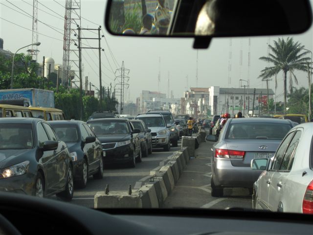
I arrived on Sunday night.  As I capture these thoughts it’s now Thursday night and I’m sitting at the airport ready to leave for home.  In these 96 hours that I’ve been here I’ve spent 20 hours driving that 50km to and from the Factory four times.  That’s a sad 20km/hr average for my journeys.  Unilever safety regulations forbid you from working on your laptop whilst in road transit in Nigeria, so this reduces one’s productivity time to a tight few hours in the office (or, in my case, the Factory), which is NOT terribly productive at all.  So I’ve spent these hours often transfixed by the passing chaos on the streets around me in my Chauffeur-driven car with my security detail alongside him in the passenger seat.  Albeit that we’ve taken mostly the same routes every day I continue to see things and places that I’d not seen in my previous days’ trips.  I can’t help but want to share some of them with you, albeit that they may have no meaning to you at all.

Enduring the daily traffic jam to / from work

Drive it to destruction ... one of MANY abandoned vehicles  in the middle of "nowhere"

Navigating the roads ahead of the rainy season

Needing a place to sit

One can buy almost anything somewhere along the road ...


Contemplating life at the end of a busy day


So much of life seems to happen alongside the main routes.  But looking down the side alleys and consciously trying to notice what was happening there I realised that life’s not restricted to these obvious main routes.  There’s a hive of activity happening not even a block away.  The place is just crawling with people doing life.  And many, it seems, probably don’t travel very far from where they live right there.  Or so it seems.  Some appear to have just gotten stuck where they are and not cared to move on.  And so they’ve ended up just ageing there, minding for and seeming to take a genuine interest in some of the little kids playing on the litter-strewn pavements, separated from the main road by a canal-come-open-sewer.  How do these people make a living?  What do they do that differentiates them from the next person that makes them marketable or capable of earning an income to stay ahead or abreast of the poverty line?  And the single informal Trader swamped by the hundreds of similar Traders around them all pedalling their similar-looking, non-unique wares.  What on earth would convince me to buy from one person and not from the next?  Clearly there’s something I don’t understand about the dynamics of this life-style that I miss out on as I am escorted past them without my camera even being able to take focus on the little girl squatting in the middle of the pavement outside of a busy shop front and relieving herself, or the kids dressed in school uniform lined up in neat rows outside of their roofless school building receiving morning instruction from the teaching staff on the days activities.  Something of this LIFE that happens amidst the chaos of scooters dodging vehicles, nobody having right-of-way, the car horn being the primary mode of communicating one’s intentions / anger / apology / presence rather than the use of an indicator; motorbikes having horns that even a 20T truck-and-trailer would be envious of!  To say it’s mayhem is a complete understatement.  But somehow it all works.  Even if it does take an inordinate amount of time to work.  When you drive, you drive fast.  When you stop, you stop for long!

One evening it took us 3hrs to make the journey home.  It turned out that a fuel tanker had somehow lost its load at a major intersection.  As we finally reached the location of the incident there was a crowd of inquisitive bystanders dodging massive pools of fuel that lay more then ankle deep in the road.  Life was still happening in the vicinity whilst this explosive threat was pouring down the street.  This delay did mean that we ended up arriving at my hotel well after dark, something I’d been directed to avoid at any cost given the heightened tensions and terrorism threats in the country.  This journey did afford me the first sightings I’d ever had in Nigeria of modified shipping containers that had been fitted with windows, mounted on old truck chassis and converted into “buses”.  I also got to see my first Nigerian / Lagosian freight trains loaded with illegal “passengers on the roof leaving town.  I’ve seen a car being washed where even the inside door panels were being hosed down thoroughly.
One evening I only got out of the Factory later, only for my driver to discover that the car battery had gone dead during the day whilst he was waiting for me.  After a mad rush about looking for jumper leads they managed to hunt down a Unilever employee who had leads; this seems to be a rarity to have these available on you.  Clearly I was “in luck”!

Unilever issued a travel advisory on my 2nd day here, changing the security status of Unilever employees from green to orange (alert) status, restricting travel into the country and certainly outside of Lagos without the Chairman’s authority.  Seems lime I made it in just in time, else this trip would have been put on hold indefinitely.  I’m not sure if the fact that I got to travel to Nigeria without question on this trip means I was lucky or unlucky in this one!

I was discovered and stopped on Unilever premises by Immigration Authorities and asked to see my papers.  Everyone in the Office (at the Factory, where this happened) was amazed that the Authorities were even on Site unannounced!  I came away unscathed and averted time in jail.  And apparently this is a good thing.  I heard from an authoritative individual today that the police service no longer have dogs or horses.  The staff (apparently) use the money to go and buy food for themselves.  Is this corruption or quiet desperation?  By inference one would not want to land up in jail for even a short time because its not sure what you’d be fed, if you’d be fed at all!

Catching a lift on a motorcycle seems to be the cheapest and most prolific form of transport.  Lagosians most certainly have an innate skill in being lifted because despite the terribly adverse on-road / off-road nature that such travel might take whilst navigating the massive and numerous pot-holes, crossing centre medians to career down the oncoming traffic lane before dodging into side streets, or just mounting the pavement to speed up the trip, the casual passenger(s) find no need to have to hold onto anything.  In fact some continue conducting business on their cell phones whilst being taken on these insane joy-rides, often even laughing and engaging with the distracted driver!  Four years ago I managed to get a photo of a passenger carrying a massive framed mirror, wedged between the passenger and the bike driver.  This time I sadly missed two classic pictures; one was the proverbial live-stock (usually a goat) being carried by the passenger.  The second was a passenger transporting a fill sized front windscreen of a vehicle, wedged between he and the driver.  How do they get that right??  I’d also previously seen a bull in the rear of a Mercedes station wagon with 4 adults in the vehicle.  Today I saw a lady loading a bull into the back of her station wagon.  Even my Nigerian colleague who was driving with me looked on in disbelief.  And here I think twice about loading my dogs into the back of my car and taking them down to the beach!!

I’m not sure why all of these “sightings” warranted comment and were imprinted onto my mind’s eye.  I wondered whether some of this happens in my world back home but I’m just so absorbed with my life that I don’t even notice it.  I’m not sure that’s the case.  I think I’d notice a lady with a bull in the back of her car.  But I think one appreciates and registers these unique sightings when one has time on one’s hands (or when you’re not behind the wheel yourself!), and when you have unique sounds, sights and smells around you.  Lagos certainly affords one those opportunities.  But it’s still a place I’m happy to visit and happier to leave.
This trip was certainly sweetened by the ease of my Sunday arrival and speedy and easy transition through customs (20mins vs 2hrs!)  You can’t be in a rush in Nigeria.  But you can always still be surprised when things do go that much smoother than planned.

I’m glad to now be headed home to be with my beloved wife who I can’t blame for not wanting to join me on this trip (despite the offer).  The luxury and delight of our recent adventure to Kenya will be a tough one to replicate.  But I know she’s going to be super-stoked to have me home again.  And I’m going to be too!!